GPS for Fishing Spots Question - VFA Website

All topics related to fishing and angling in Victoria that don't fit into one of the other forum categories.
Waverley73
Rank: Baitfish
Rank: Baitfish
Joined: Tue May 08, 2018 8:25 am

GPS for Fishing Spots Question - VFA Website

Post by Waverley73 » Fri Oct 05, 2018 10:15 am

Hi there. I was looking at this Victorian Fisheries Authority website and it lists different fishing spots and for each of them there is a photo with what looks like GPS co-ordinates but when I try to find the spots on Google Maps it has become clear the numbers aren't the traditional long / lat co-ordinates so does anyone know what they are (and how to find those exact spots using those numbers?

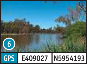
Eg, for Lake Benalla it has this: GPS E409027 N5954193 but these numbers don't make a lot of sense.

https://vfa.vic.gov.au/recreational-fis ... ke_Benalla

Image

Cheers guys \m/

User avatar
Sinsemilla
Rank: Gummy Shark
Rank: Gummy Shark
Joined: Fri Apr 29, 2016 2:35 pm
Location: Northern Subs
Likes received: 272 times

Re: GPS for Fishing Spots Question - VFA Website

Post by Sinsemilla » Fri Oct 05, 2018 10:45 am

I'm not 100% but i don't think they are complete coordinates. I think they are missing the last numbers because they aren't giving you an exact spot but the coordinates of an area. I could be wrong though..

Cheers, Anth

Mattblack
Rank: Gummy Shark
Rank: Gummy Shark
Joined: Tue Sep 06, 2016 1:08 pm
Location: South East Suburbs
Has liked: 625 times
Likes received: 298 times

Re: GPS for Fishing Spots Question - VFA Website

Post by Mattblack » Fri Oct 05, 2018 10:51 am

Doesn't make sense to me either...it should be E 145.58 S 36.33 'ish'

https://www.gps-coordinates.net/gps-coo ... -converter

Waverley73
Rank: Baitfish
Rank: Baitfish
Joined: Tue May 08, 2018 8:25 am

Re: GPS for Fishing Spots Question - VFA Website

Post by Waverley73 » Fri Oct 05, 2018 10:53 am

Thanks for the reply. Yeah, I reckon it's weird that they have published those pics with those numbers when they don't appear to be actual GPS co-ords to those spots - not sure why they would even put them on there.

Here's Lake Benalla on Google Maps and the actual co-ords for it (well the part of the lake I selected) is in the URL (36.5495 S / 145.9769 E which when you look at the numbers on that site for there it has no correlation at all.

https://www.google.com.au/maps/place/La ... 45.9769353

Waverley73
Rank: Baitfish
Rank: Baitfish
Joined: Tue May 08, 2018 8:25 am

Re: GPS for Fishing Spots Question - VFA Website

Post by Waverley73 » Fri Oct 05, 2018 10:54 am

Mattblack wrote:Doesn't make sense to me either...it should be E 145.58 S 36.33 'ish'

https://www.gps-coordinates.net/gps-coo ... -converter
Exactly mate. It might be some other method of GPS - hopefully someone recognises it.

Waverley73
Rank: Baitfish
Rank: Baitfish
Joined: Tue May 08, 2018 8:25 am

Re: GPS for Fishing Spots Question - VFA Website

Post by Waverley73 » Fri Oct 05, 2018 11:46 am

I've found the answer - they're using some weird alternative (to using long / lat) Dutch method called UTM.

https://en.wikipedia.org/wiki/Universal ... ate_system

https://www.geoplaner.com/

I wonder if the fisheries dudes really don't want ppl at those spots lol.

User avatar
re-tyred
Moderator
Moderator
Joined: Tue Dec 27, 2011 5:54 am
Location: Lakes Entrance
Has liked: 375 times
Likes received: 937 times

Re: GPS for Fishing Spots Question - VFA Website

Post by re-tyred » Fri Oct 05, 2018 2:13 pm

All fisheries/ state based government use UTM. it is the basic form of positioning for survey work. Conversion is easy. Just google UTM to Lat long.
Alternatively open google earth. Go to setting change the coordinates to UTM. Create a mark and enter the utm numbers. Go back to settings and change to deg min decimal minute. Look at the mark properties and it will be in lat long.
There's nothing . . . absolutely nothing . . . half so much worth doing as simply messing around in boats.
Kenneth Grahame, The Wind in the Willows (River Rat to Mole)

ChuckH
Rank: Banjo
Rank: Banjo
Joined: Tue Sep 04, 2018 3:35 am

Re: GPS for Fishing Spots Question - VFA Website

Post by ChuckH » Fri Oct 05, 2018 11:34 pm

If you’ve got an iPhone I downloaded an app called coordinates a while ago, there’s about 6 or so different formats for gps coordinates, it’s a free app and quite easy to use

ChuckH
Rank: Banjo
Rank: Banjo
Joined: Tue Sep 04, 2018 3:35 am

Re: GPS for Fishing Spots Question - VFA Website

Post by ChuckH » Fri Oct 05, 2018 11:37 pm

Here’s a screenshot of the apps gps options
Attachments
6E467E41-8A20-4593-AAC3-5E629C0C3034.png

fishnut
Rank: Bream
Rank: Bream
Joined: Sat Sep 20, 2014 6:42 pm
Location: Altona meadows
Has liked: 28 times
Likes received: 220 times

Re: GPS for Fishing Spots Question - VFA Website

Post by fishnut » Sat Oct 06, 2018 1:42 am

Maybe they are using a different datum and not wgs84

Post Reply

Return to “General”