
I think we all can agree that COVID-19 has changed not only the way we fish, but also the locations we fish.
As someone who previously predominantly fished landbased piers and structures, making the change to those remote rockwalls and beaches has been a learning curve.
Satellite Imaging gives us the advantage to scope out new fishing spots before we even hit the water, but it has its own challenges.
These are a great resource for identifying those key submerged structures, drop offs and weed patches from home.
Searching around I've found the online resources of Zoom Earth and Google Earth having advantages and disadvantages.
Zoom looks to have a clearer imagine in shallow water and creates a better image, while Google Maps contrast makes some less noticeable drop offs more visible. Zoom Earth has my preference.
Port Phillip Bay: https://zoom.earth/#view=-38.13645,144. ... ayers=esri
Western Port Bay: https://zoom.earth/#view=-38.375399,145.341129,12z
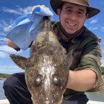
Here are a few examples between the maps of my new favourite flathead spot off Clifton Springs, Victoria.
Zoom Earth Wide Shot